
Etosha National Park Map: Gates, Waterholes & Safari Routes 2026 Guide
Planning a Namibia safari? The Etosha National Park map is your most powerful tool for designing an itinerary that maximizes wildlife sightings, minimizes backtracking, and fits your time and budget.
It highlights the park’s main entrance gates, camps, roads, waterholes, picnic sites, and top wildlife viewing areas, helping visitors navigate with confidence.
This complete 2026 Etosha map guide breaks down every gate, waterhole, camp, and self‑drive route so you can plan like a pro—then let Muzungu Africa Safaris turn your plan into a seamless, tailor‑made Namibia safari experience.
If you’re planning a self-drive adventure or a guided safari, the map makes it easy to locate iconic attractions such as Okaukuejo, Halali, Namutoni, and the vast Etosha Pan.
Whether you’re flying in from the USA, UK, Europe, Canada, Asia, China, Latin America, Oceania, or the Middle East, this guide gives you the exact map‑based strategy used by top safari planners to unlock Etosha’s best game viewing while avoiding common routing mistakes.
Understanding the Etosha National Park map allows travelers to choose the best routes, maximize game-viewing opportunities, and enjoy a safe, well-organized safari while exploring Namibia’s spectacular landscapes and diverse wildlife.
Every year, thousands of travelers arrive at Andersson Gate with nothing but a blurry screenshot and high hopes — only to miss the best waterholes, drive past leopard sightings, and waste precious daylight on dead-end tracks.
Etosha National Park spans 22,935 km² in northern Namibia — roughly the size of Israel — and remains Africa’s most accessible big-game destination.
Four main gates, over 40 waterholes, five rest camps, and hundreds of kilometers of graded roads make it ideal for independent self-drive safaris. But only if you know where to go.
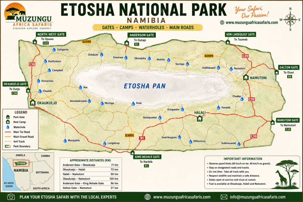
How to Use the Etosha Map for Your Safari
If you’re short on time, here’s the essence of using the Etosha National Park map effectively:
-
Five main gates: Anderson, Von Lindequist, Namutoni, Galton, and King Nehale—each serves a different approach route and part of the park.
-
Best waterholes:
-
Elephants & general game: Okaukuejo, Halali, Klein Namutoni.
-
Lions & predators: Oker Semana, Sueda, Chudop.
-
Black rhino: Okaukuejo and Oker Semana.
-
-
Self‑drive routes: Most visitors drive a triangular or figure‑of‑eight route between Okaukuejo, Halali, and Namutoni, adding side loops to waterholes. Plan 2–3 days minimum inside the park.
-
Where to stay: Inside the park: NWR rest camps (Okaukuejo, Halali, Namutoni, and Onkoshi). Outside: private lodges in Ongava, Olifantsrus, and Dolomite areas for exclusivity and night drives.
-
Best time: Dry season (May–October) concentrates animals at waterholes, making the map even more valuable for planning daily circuits.
Want a custom Etosha route built around your exact dates and interests? Contact Muzungu Africa Safaris for a free, no‑obligation quote on a tailor‑made Namibia safari.
Etosha National Park Overview: Why the Map Matters
Etosha National Park is one of Africa’s greatest wildlife strongholds, covering over 22,270 km² in northern Namibia.
The park is dominated by the Etosha Pan, a vast, shimmering salt pan visible from space, surrounded by mopane woodlands, grasslands, and scattered waterholes.
Key wildlife highlights:
-
Large herds of elephants and plains game (zebra, springbok, wildebeest, oryx).
-
Healthy populations of lions, leopards, cheetahs, and hyenas.
-
Notable black rhino sightings, especially around Okaukuejo and Oker Semana.
-
Over 340 bird species, including flamingos on the pan in wetter periods.
For visitors, Etosha is exceptionally safari‑friendly: well‑maintained gravel roads, clearly marked waterholes, and reliable wildlife viewing—especially in the dry season when animals cluster around limited water sources.
This makes an accurate Etosha National Park map essential for planning where to go, when, and from which gate.
Overview of the Etosha National Park Map
A professional Etosha National Park map is more than a tourist handout — it’s a strategic planning tool that determines every hour of your Namibia wildlife safari.
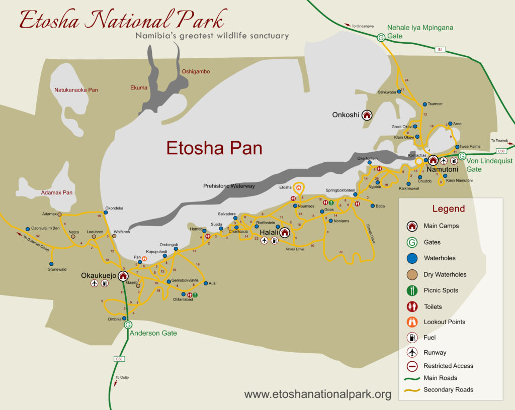
How to read the Etosha map:
- Road network — Graded gravel roads (white) connect all major camps and gates. 4×4 tracks (dashed lines) access remote waterholes. Tar roads (solid black) exist only near Andersson Gate.
- Etosha Pan — The massive white salt flat in the center. Wildlife concentrates at its edge during the dry season.
- Camps — Marked with tent icons. NWR rest camps (Okaukuejo, Halali, Namutoni, Onkoshi, Dolomite) sit inside the park. Private lodges cluster outside the gates.
- Gates — Four main entry points (Andersson, Von Lindequist, Galton, King Nehale) with strict sunrise-to-sunset hours.
- Waterholes — The most critical symbols. Permanent waterholes (blue dots) hold water year-round. Seasonal waterholes (orange dots) dry up November–March.
- Picnic sites — Shaded rest areas with toilets. Essential for full-day game drives.
- Viewpoints — Elevated platforms overlooking the Etosha Pan or Fischer’s Pan.
💡 Pro tip: Print your Etosha map and mark your planned waterholes with a highlighter. Cross them off as you visit. This simple system prevents missed sightings and helps guides track your route if you break down.
Size of Etosha National Park
Etosha National Park covers 22,935 km² — making it one of the largest protected areas in southern Africa. To put this in perspective:
Table
|
Park |
Size (km²) |
Comparison to Etosha |
|
Etosha National Park |
22,935 |
Baseline |
|
Serengeti National Park (Tanzania) |
14,763 |
Etosha is 55% larger |
|
Kruger National Park (South Africa) |
19,485 |
Etosha is 18% larger |
|
Yellowstone National Park (USA) |
8,984 |
Etosha is 2.5x larger |
The Etosha Pan alone spans 4,800 km² — roughly 20% of the entire park. This vast salt flat creates a white desert that forces wildlife to the perimeter, creating the highest game-viewing density in Namibia.
Ecosystems within Etosha:
- Mopane woodland — dominates the southern and eastern sectors
- Acacia savanna — central plains, prime grazing
- Grassland — eastern sector, springbok stronghold
- Salt pan — the white heart, extreme but mesmerizing
- Dolomite hills — western sector, rocky outcrops, leopard territory
📏 Scale matters: Driving from Andersson Gate to King Nehale Gate takes 4+ hours on graded roads. Plan your Etosha itinerary with realistic distances — this isn’t a park you rush.
Where is Etosha National Park Located?
Etosha National Park is located in northern Namibia, approximately 435 km north of Windhoek along the B1 highway.
The park anchors the Kunene Region, bordered by the Oshikoto Region to the east and the Oshana Region to the west.
Key location facts:
- Distance from Windhoek: 435 km (4.5 hours by tar road)
- Distance from Swakopmund: 530 km (6 hours via Outjo)
- Nearest towns: Outjo (90 km south), Tsumeb (100 km east), Ondangwa (120 km north)
- GPS coordinates: 18.8556° S, 16.3464° E
The park’s position in northern Namibia places it within the savanna biome, where the Kalahari Desert meets the Etosha Pan – a 4,800 km² salt flat that defines the entire ecosystem.
This unique geography creates one of Africa’s highest wildlife densities around the pan’s perimeter.
Regional context: Etosha connects seamlessly with other Namibia safari destinations. Combine it with Damaraland (260 km west), the Skeleton Coast (400 km northwest), or the Waterberg Plateau (300 km south) for a complete Namibia road trip.
🎯 Planning a multi-destination Namibia safari? Get a Custom Namibia Itinerary from Muzungu Africa Safaris — We connect Etosha with Sossusvlei, Damaraland, and the Skeleton Coast.
Related reads: Namibia Safari | Best Time to Visit Namibia
Etosha Map: Gates, Entry Points and When to Use Each
Etosha has five main gates, each suited to different itineraries and origins.
Understanding them on the map helps you avoid unnecessary detours and maximize game‑viewing time.
1. Anderson Gate (South‑west)
-
Location: Near Outjo, on the main route from Windhoek and Swakopmund.
-
Best for: Visitors driving from central or western Namibia, or combining Etosha with Damaraland and the Skeleton Coast.
-
Map strategy: Enter here, head north to Okaukuejo, then loop east towards Halali and Namutoni before exiting via another gate if doing a one‑way route.
2. Von Lindequist Gate (East)
-
Location: Near Tsumeb, on the main tar road from Windhoek via Otjiwarongo.
-
Best for: Fly‑in guests via Tsumeb or those traveling from eastern Namibia and Botswana.
-
Map strategy: Ideal for a one‑way circuit: enter at Anderson, exit at Von Lindequist (or vice versa), minimizing backtracking.
3. Namutoni Gate (Far east)
-
Location: Close to Namutoni camp and the eastern edge of the park.
-
Best for: Visitors focusing on the eastern sector or combining Etosha with the Caprivi/Zambezi Region.
-
Map strategy: Use if your itinerary includes the far‑east waterholes and you plan multiple nights in Namutoni camp.
4. Galton Gate (North‑west)
-
Location: Accessible via the Dolomite Route; more remote and less crowded.
-
Best for: Adventure‑focused travelers, photographers seeking quieter areas, and those staying at western private concessions.
-
Map strategy: Combine with Okaukuejo and western waterholes; check road conditions and opening times before planning.
5. King Nehale Gate (North)
-
Location: Northern boundary, closer to Ongava and private reserves.
-
Best for: Guests staying at exclusive lodges in the Ongava area or those approaching from northern Namibia.
Map strategy: Useful for one‑way itineraries that start or end in private concessions, giving you flexible entry and exit options.
Tip: When you book with Muzungu Africa Safaris, we recommend the optimal gate combination based on your full Namibia route, flight schedule, and preferred pace.
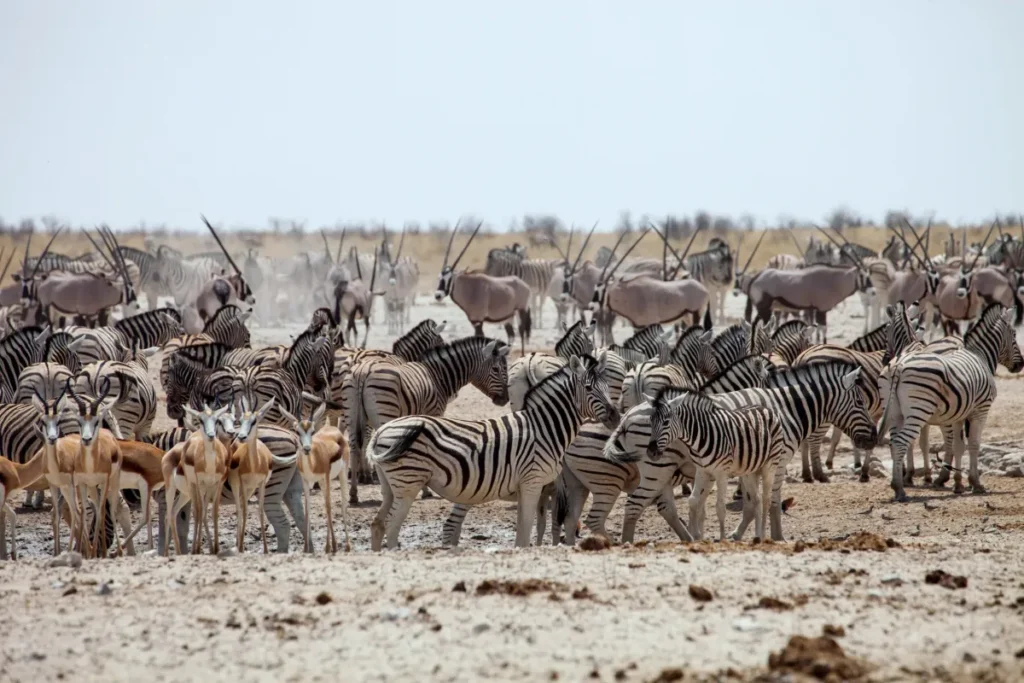
Wildlife Viewing Etosha Waterholes Map: Where to See Elephants, Lions & Rhinos
On the Etosha waterholes map, not all dots are equal. Some waterholes are legendary for specific species or photo opportunities.
Focus your driving time where it counts.
Best Waterholes for Elephants
-
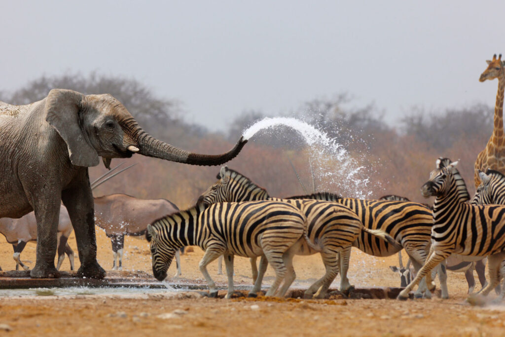
Okaukuejo Waterhole: Arguably Etosha’s most famous, with a floodlit viewing area at Okaukuejo Camp. Excellent for large elephant herds and mixed species, especially at dusk.
-
Halali Waterhole: Another reliable elephant spot, with good sighting opportunities throughout the day.
-
Klein Namutoni / Namutoni area: Strong elephant presence, especially in dry months.
Best Waterholes for Lions and Predators
-
Oker Semana: Regular lion sightings, often with cubs; also good for hyenas and leopards.
-
Sueda & Chudop: Favorable for lions hunting plains game; open vistas make photography easier.
-
Halali vicinity: Predators patrol the edges, especially early morning and late afternoon.
Best Waterholes for Black Rhino
-
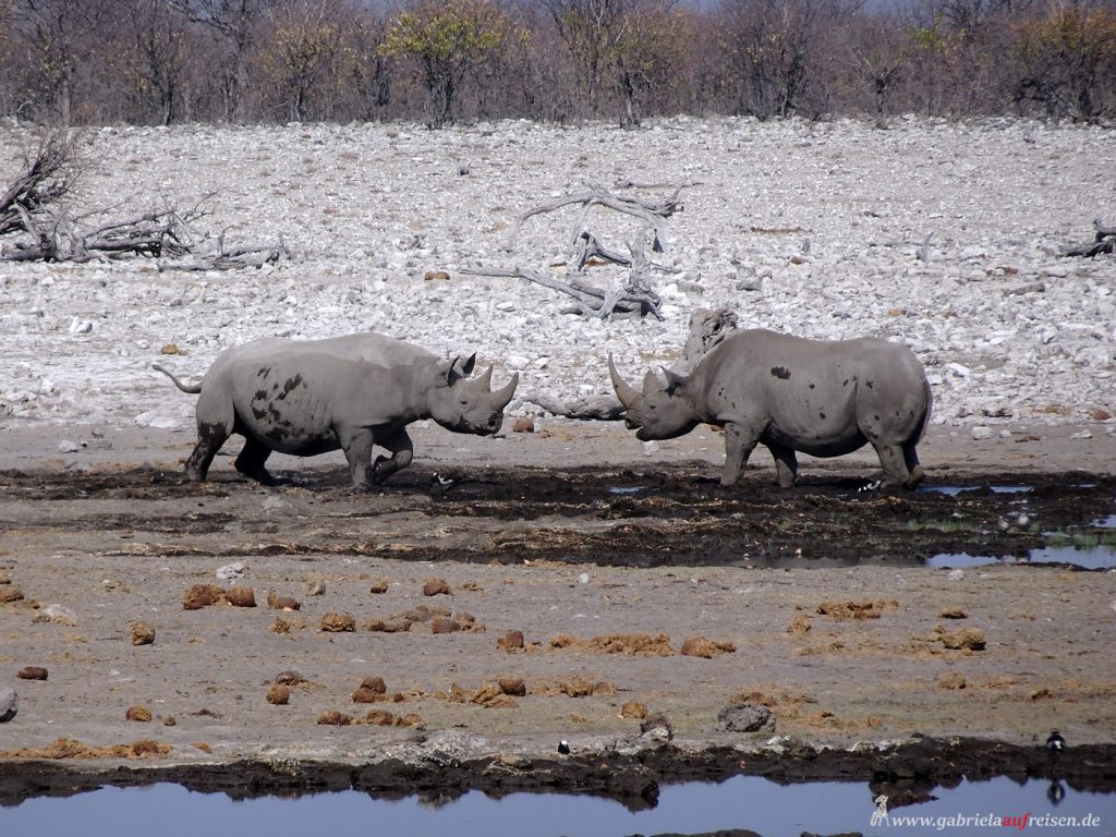
Okaukuejo and Oker Semana: Among the most reliable spots in Etosha for black rhino, though sightings are never guaranteed.
-
Patience and quiet observation at these waterholes significantly increase your chances.
Best Waterholes for Birds and General Game
-
Fisher’s Pan, Ombika, and pan‑edge waterholes: Excellent for birdlife, especially in and after the rainy season when the main Etosha Pan holds water and attracts flamingos.
-
Mopane‑belt waterholes: Great for zebra, springbok, oryx, and wildebeest concentrations.
Pro tip: Mark your top 6–8 waterholes on the map and plan loops rather than out‑and‑back drives. This saves fuel and time, and increases your chances of varied sightings.
Attractions Near Etosha National Park
Etosha anchors a Namibia safari circuit that rivals any in Africa. Use your Etosha map as the starting point for these nearby destinations:
Table
|
Attraction |
Distance from Etosha |
Why Visit |
|
Ongava Game Reserve |
10 km (Andersson Gate) |
Walking safaris, rhino tracking, luxury lodges |
|
Etosha Pan (pan drives) |
Inside park |
Salt flat landscapes, mirage photography |
|
Otjikoto Lake |
120 km east |
Sinkhole diving, German colonial history |
|
Waterberg Plateau |
300 km south |
Endangered species, hiking trails, luxury lodges |
|
Damaraland |
260 km west |
Desert elephants, Twyfelfontein rock art, Brandberg Mountain |
|
Skeleton Coast |
400 km northwest |
Shipwrecks, seal colonies, desert meets ocean |
|
Twyfelfontein |
280 km west |
UNESCO rock engravings, 2,000+ year old art |
🌍 Building a Namibia road trip? Get a Custom Multi-Destination Itinerary from Muzungu Africa Safaris — We connect Etosha with Damaraland, Sossusvlei, and the Skeleton Coast.
Best Self‑Drive Routes and Distances Inside Etosha
Etosha is big, and distances add up. A good Etosha self‑drive map includes approximate distances so you can plan realistic daily circuits.
Below are typical driving times and distances between key points (approximate, on gravel):
-
Anderson Gate → Okaukuejo: ~17–70 km (20–30 min to 1–1.5 hours, depending on route and stops).
-
Okaukuejo → Halali: ~74 km (1.5–2 hours, with stops at Salvadora, Rietfontein).
-
Halali → Namutoni: ~70–75 km (1.5–2 hours).
-
Namutoni → Von Lindequist Gate: ~20 km (20–30 minutes).
-
Okaukuejo → Oker semana (via side loops): ~20–30 km extra depending on route.
Important: The park speed limit is 60 km/h on gravel, so allow 2–3 hours per leg, more if you stop at waterholes. Always reach your camp before gate closing.
Classic Triangular Route (3 Days Minimum)
-
Day 1: Enter via Anderson Gate → Okaukuejo. Explore the Okaukuejo waterhole and nearby loops. Overnight Okaukuejo.
-
Day 2: Okaukuejo → Halali, with detours to Oker Semana and Sueda. Overnight Halali.
-
Day 3: Halali → Namutoni, exploring eastern waterholes. Exit via Von Lindequist or Namutoni Gate.
One‑Day Highlight Loop
If you only have one day:
-
Enter via Anderson Gate → Okaukuejo → Halali → return to Okaukuejo and exit via Anderson.
-
Focus on Okaukuejo, Oker Semana, and Halali waterholes.
This is where a clear Etosha National Park map with distances helps you avoid overambitious plans on gravel roads.
Note: Self‑drive is popular, but a guided safari with Muzungu Africa Safaris means an experienced driver‑guide who knows the best current animal movements, hidden turnoffs, and photo spots—turning a good map into an exceptional experience.
Self-Drive Tips for Etosha National Park
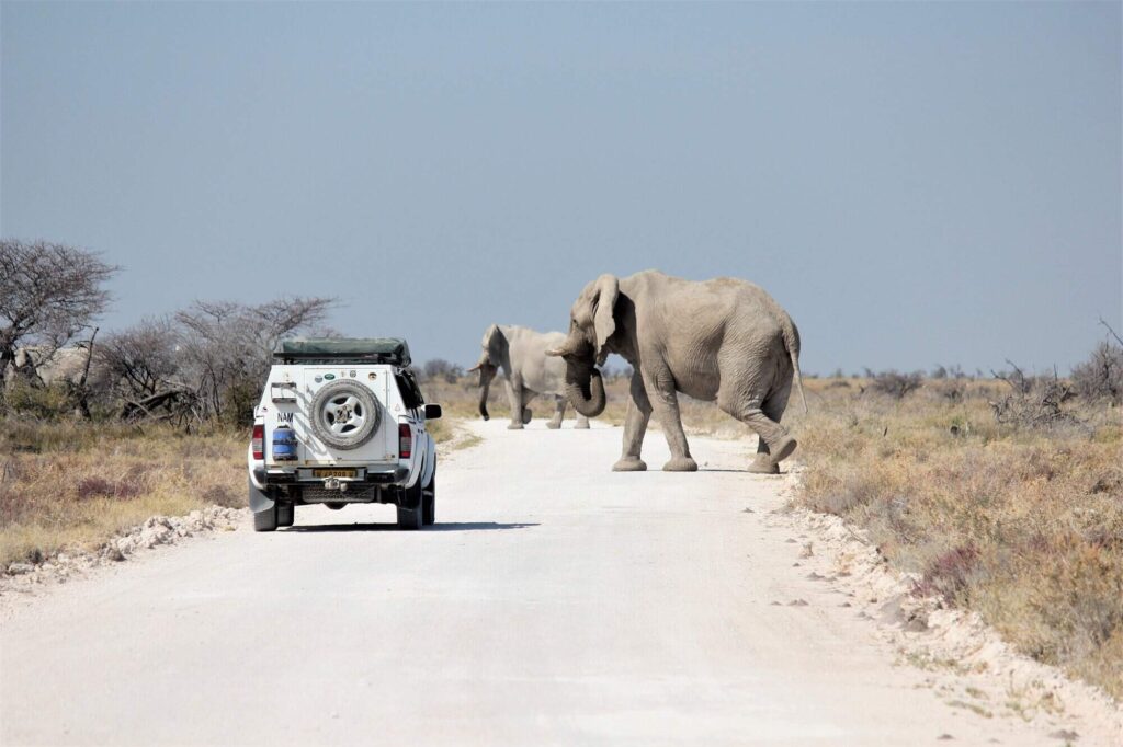
Follow these rules and your Etosha self-drive safari will be safe, productive, and unforgettable:
1. Fuel
- Fill up at Okaukuejo or Namutoni — the only fuel stations inside the park
- Carry a 20-liter jerry can as backup
- Unleaded petrol and diesel both available
2. Tyres
- Check pressure daily — gravel roads are harsh
- Carry two spares — punctures are common
- 4×4 vehicles: Reduce pressure to 1.8 bar on rough tracks
3. Food
- Stock up in Windhoek or Outjo — camp shops have limited selection
- Braai facilities at all camps — buy meat and charcoal at camp shops
- Restaurant meals available at Okaukuejo, Halali, and Namutoni
4. Water
- Carry 5 liters per person per day — dehydration risk is real
- Tap water at camps is safe — refill bottles daily
5. Safety
- Never leave your vehicle outside designated areas
- No night driving except between camps and floodlit waterholes
- Lock doors — baboons and hyenas are opportunistic
6. Navigation
- Download offline maps before entering
- Carry a printed Etosha map as backup
- Mark your planned route with a highlighter
🛡️ Safety first. Muzungu Africa Safaris provides 24/7 support to all booked clients — Satellite phone, medical evacuation cover, and local expertise.
Where to Stay: Camps and Lodges on the Etosha Map
Your accommodation choice shapes your daily routes. On the Etosha map with camps, you’ll see four main Namibia Wildlife Resorts (NWR) rest camps inside the park, plus numerous private lodges just outside.
Inside the Park (NWR Camps)
-
Okaukuejo Camp: Central location, excellent waterhole, floodlit viewing, restaurant, and fuel. Perfect base for predator and rhino focus.
-
Halali Camp: Near the “Mokonde” waterhole and close to Oker Semana; great for lions and general game.
-
Namutoni Camp: Eastern sector base, near historic Namutoni Fort and diverse eastern waterholes.
-
Onkoshi Camp: More exclusive, on the northern edge of the pan; ideal for photographers and those seeking solitude.
Outside the Park (Private Lodges & Concessions)
-
Ongava Game Reserve: Shares unfenced boundaries with Etosha’s western side; offers night drives, walking safaris, and exclusive vehicles.
-
Olifantsrus and other western concessions: Fantastic for low‑density, high‑quality wildlife experiences with easy access to Okaukuejo and western waterholes.
-
Dolomite Camp area: Remote, exclusive western section with modern eco‑style tents and chalets.
Staying partly inside and partly outside the park gives you the best of both worlds: easy access to public waterholes plus exclusive activities. Muzungu Africa Safaris can build itineraries that mix NWR camps with private lodges according to your budget and style.
Sample 1‑Day, 2‑Day and 3‑Day Etosha Itineraries (With Map)
Use these templates and adapt them on your Etosha safari routes map.
1‑Day Etosha Itinerary (Highlights)
-
Early entry via Anderson Gate.
-
Drive to Okaukuejo, stop at key waterholes en route.
-
Morning game drive around Okaukuejo and Oker Semana.
-
Picnic lunch (inside designated areas).
-
Afternoon loop towards Halali and back.
-
Exit via Anderson Gate late afternoon.
Best for: Travelers on a tight schedule, combining Etosha with Damaraland or Swakopmund.
2‑Day Etosha Itinerary (Balanced)
-
Day 1: Anderson Gate → Okaukuejo. Explore the Okaukuejo waterhole and nearby loops. Overnight Okaukuejo.
-
Day 2: Okaukuejo → Halali → back to Okaukuejo or towards Anderson, focusing on Oker Semana and Sueda. Exit late afternoon.
Best for: Visitors wanting a solid taste of Etosha without a long stay.
3‑Day Etosha Itinerary (Recommended Minimum)
-
Day 1: Anderson Gate → Okaukuejo. Explore western waterholes. Overnight Okaukuejo.
-
Day 2: Okaukuejo → Halali via predator‑rich loops. Overnight Halali.
-
Day 3: Halali → Namutoni, explore eastern waterholes. Exit via Von Lindequist or Namutoni Gate.
Best for: Most first‑time visitors; allows relaxed driving, multiple waterholes, and better wildlife opportunities.
For each itinerary, we can overlay exact routes, suggested picnic stops, and optimal times at each waterhole when you book with Muzungu Africa Safaris.
Best Time to Visit Etosha for Wildlife and Photography
Timing changes how you use the Etosha National Park map.
Dry Season (May–October)
-
Water is scarce; animals concentrate at permanent waterholes.
-
Best for general game viewing, elephants, predators, and rhinos.
-
Clear skies and cooler mornings/evenings are ideal for photography.
Wet Season (November–April)
-
Water is widespread; animals disperse, making sightings more spread out.
-
Lush landscapes, migrant birds, and dramatic cloud formations over the pan.
-
Better for birdwatchers and photographers who prefer green scenery.
For classic “map‑based” safari planning focused on big game, the dry season is usually best.
Practical Tips: Fuel, Roads, Park Fees and Safety
To make your Etosha map planning realistic:
-
Fuel: Available at Okaukuejo, Halali, and Namutoni. Fill up whenever you can; distances are long.etoshanationalpark.com+1
-
Roads: Main routes are gravel but well‑maintained; drive slowly (often 40–60 km/h) to avoid damage and spot wildlife.
-
Park fees (2026): International adult: NAD 280/day; vehicle (≤10 seats): NAD 60/day. Payment at gate; carry ID.
-
Safety: Stay in your vehicle except at designated areas; respect gate opening/closing times; keep a safe distance from animals.
-
Connectivity: Mobile signal is limited; download offline maps and this guide before you enter the park.
Frequently Asked Questions
Where is Etosha National Park located?
Etosha National Park is in northern Namibia, 435 km north of Windhoek. It sits in the Kunene Region, bordered by the Oshikoto and Oshana Regions.
How many gates does Etosha have?
Four main gates: Andersson Gate (south), Von Lindequist Gate (east), Galton Gate (west), and King Nehale Gate (north).
Can I drive myself in Etosha?
Yes. Etosha is Africa’s best self-drive safari destination. Graded gravel roads connect all major camps and waterholes. 4×4 is only needed for the western sector.
Which gate is closest to Windhoek?
Andersson Gate — 435 km from Windhoek via the B1 highway and C38 road.
Which camp is best in Etosha?
Okaukuejo for first-timers (famous floodlit waterhole). Halali for photographers (central location, leopard). Dolomite for exclusivity (western wilderness, limited access).
Is Etosha suitable for first-time visitors?
Absolutely. Etosha is Namibia’s most accessible national park — paved roads near the gate, clear signage, abundant wildlife, and excellent camp facilities.
Can Google Maps be used inside the park?
Limited. Cell signal is patchy, and Google Maps doesn’t show waterholes, camps, or road conditions. Download offline maps or use our free PDF map.
How long does it take to cross Etosha?
4–5 hours from Andersson Gate to King Nehale Gate on graded roads. Add time for game drives and waterhole stops.
Where are the best waterholes in Etosha?
Okaukuejo (elephant, rhino), Halali (leopard, hyena), Okondeka (cheetah), Goas (springbok, zebra), and Nebrownii (lion).
Is a printed map necessary for Etosha?
Highly recommended. Digital devices fail. Our free printable Etosha map works offline and shows all waterholes, camps, and distances.
Are roads paved in Etosha?
Only near Andersson Gate. The rest are graded gravel. Western tracks require 4×4.
Is Etosha safe for tourists?
Yes. Etosha is one of Africa’s safest national parks. Follow park rules: stay in your vehicle, no night driving, lock doors at camps.
Can I visit Etosha in one day?
Yes, but not recommended. A one-day Etosha safari gives you a taste, but you’ll miss dawn and dusk — the best wildlife hours. Minimum 2 nights recommended.
Which entrance should I use for Etosha?
Andersson Gate for Windhoek arrivals and first-timers. Von Lindequist Gate for Tsumeb or eastern Namibia access. Galton Gate for Dolomite and western wilderness. King Nehale Gate for northern Namibia routes.
Plan Your Etosha Safari with Muzungu Africa Safaris
A map is powerful—but a tailored itinerary built by experts is transformative.
At Muzungu Africa Safaris, we:
-
Design custom Etosha routes based on your travel dates, interests (photography, rhinos, family‑friendly pacing), and accommodation style.
-
Combine Etosha with the rest of Namibia (Damaraland, Skeleton Coast, Sossusvlei, Zambezi Region) into seamless, logistically smooth journeys.
-
Handle all bookings: park fees, NWR camps, private lodges, transfers, and optional activities (night drives, guided walks, scenic flights).
Whether you want a self‑drive‑friendly plan with detailed maps or a fully guided safari with a knowledgeable driver‑guide, we’ll turn your Etosha National Park map into a real, unforgettable experience.
Ready to start? Contact Muzungu Africa Safaris today for a free, no‑obligation Etosha and Namibia safari quote tailored to your dates and budget.
Book Your Next African Adventure with Muzungu Africa Safaris
From the salt‑pan horizons of Etosha to the mist‑shrouded volcanoes of Uganda and Rwanda, Muzungu Africa Safaris specializes in high‑impact, tailor‑made safaris for travelers from the USA, Canada, the UK, Europe, Asia, China, Latin America, Oceania, and the Middle East.
-
Etosha & Namibia safaris: Custom routes built around the best gates, waterholes, and camps.
-
Gorilla trekking in Uganda & Rwanda: Expertly guided mountain gorilla permits and itineraries in Bwindi, Mgahinga, and Volcanoes National Parks.
-
East Africa combinations: Add the Serengeti, Masai Mara, or Okavango for a multi-country wildlife epic.
Don’t leave your once‑in‑a‑lifetime safari to chance.
Contact Muzungu Africa Safaris now to
-
Get a free, personalized safari quote for Etosha, gorilla trekking, or combined African adventures.
-
Secure prime gorilla permits and top‑rated camps well in advance.
-
Travel with confidence, backed by local expertise and end‑to‑end support.
Book your Etosha safari—and your gorilla permit—through Muzungu Africa Safaris today, and turn your dream African journey into a flawlessly executed reality.